Chapter 6 — What is there
What is within reach of a stop?
Written by an AI assistant
This page was planned, built and written by Claude. The prose is hand-written; every number in it was injected from the computation at build time. Rebuilt 2026-08-15 11:42 UTC.
A stop with nothing near it is a stop nobody uses. This chapter puts the two halves together: the destinations people actually travel to, and how many of them the network in chapter 1 reaches.
OpenStreetMap is not an official dataset. It is a volunteered map, which means its coverage varies by how interested local mappers are. In a British city centre that coverage is very good — and "very good" is not "complete", which is a different claim from anything else in this atlas.
Three ways to be refused
Overpass rejected this chapter three times before it returned anything, and each refusal looked like a different problem from the one it was.
1. It is a POST, not a GET. The query goes in the body of the request, not in the URL. Sending it as a GET is the natural first attempt.
2. It refuses the default client. With requests' own User-Agent,
Overpass answers 406 Not Acceptable — an HTTP status that reads like a
malformed query. It is not: the server is declining an unidentified client.
Setting a User-Agent that names the project and gives a contact fixes it
instantly, and no amount of adjusting the query ever would. This one cost the
most time, because every instinct says a 406 is your fault for asking badly.
3. amenity and shop are different keys. Schools, colleges,
universities, hospitals and pharmacies are amenity. Supermarkets are shop.
A query that assumes one key returns five full categories and one empty one —
and an empty category reads as "there are none here" rather than as a bug.
What the patch holds
282 everyday destinations in six categories:
| Category | Count |
|---|---|
| Schools | 102 |
| Supermarkets | 68 |
| Pharmacies | 63 |
| Colleges | 19 |
| Universities | 15 |
| Hospitals | 15 |
These are counts of mapped objects, and an object is not a measure of size. A 2,000-pupil secondary school and a 200-pupil primary are both one school. A hospital site with fifteen buildings may be one object or fifteen depending on how it was mapped.
What the network reaches
100.0% of these destinations are within 400 m of a public transport stop. Every single one. The furthest is 366 m away.
That is a real answer and a useless test. A threshold everything passes has told you nothing, and the first version of the figure below made it unmissable: six bars, all at 100%, neatly arranged.
So the question has to be sharpened. Not does the network reach these places, which is settled, but how close does it get, and to what:
| Within 100 m | Within 200 m | Median | |
|---|---|---|---|
| All destinations | 55% | 89% | 91 m |
By category the differences are real. Supermarkets and pharmacies sit at a median of about 60 m — they are on the network, because shops and bus routes both follow high streets. Schools sit further back, at a median of 137 m, because schools are built where there is land.
Compare this with chapter 1, which found 91% of the area within 400 m of a stop. Area coverage counts empty ground equally; this counts destinations. A network can serve most of the map and still miss the hospital. This one does not — but that had to be measured rather than assumed.
The figures
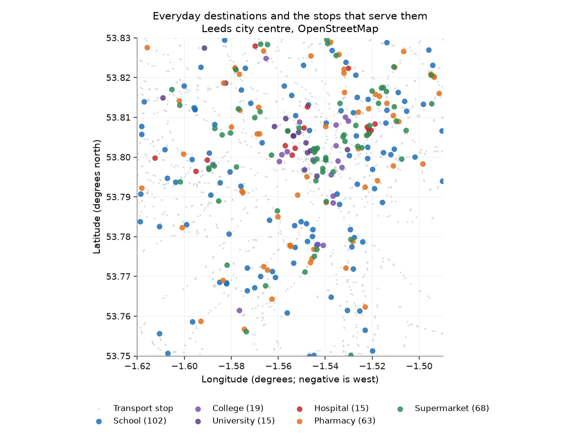
Six kinds of everyday destination, over the transport stops from chapter 1 in grey.
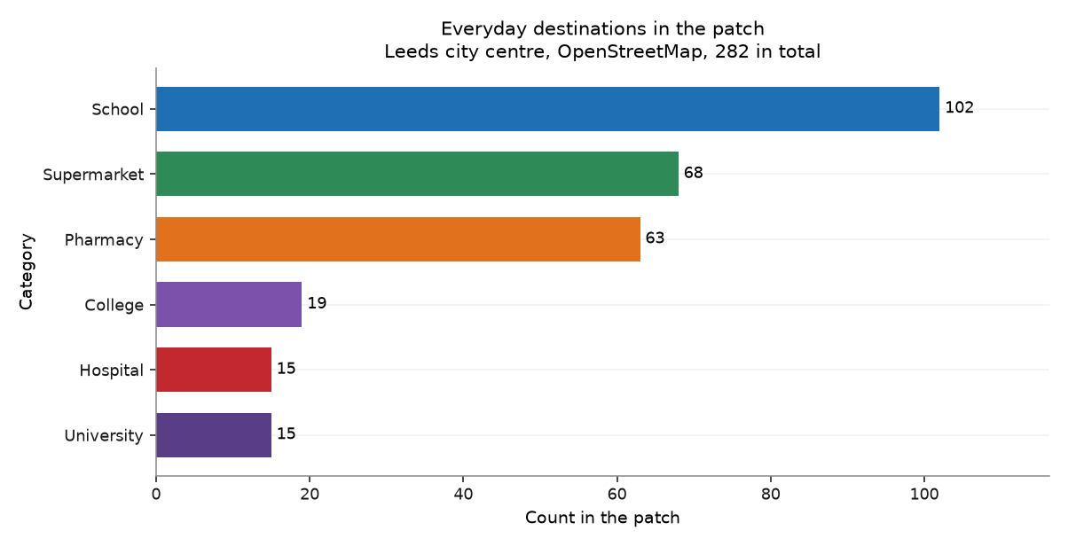
What the patch contains, by category. These are counts of mapped objects, not of floor space or capacity: one large secondary school and one small primary count the same.
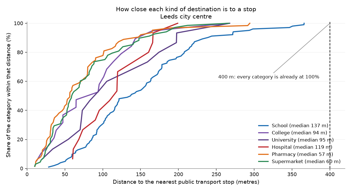
Distance from each kind of destination to the nearest stop. The 400 m threshold is not a useful test in this patch, because everything clears it, so the curves show where the categories actually differ. Pharmacies and supermarkets sit on the network; schools sit back from it.
What it shows
- The patch contains 282 everyday destinations across six categories, dominated by 102 schools and 68 supermarkets.
- 100.0% of them are within 400 m of a public transport stop, so the network reaches the places people go, not only the ground they stand on.
- OpenStreetMap coverage in a British city centre is good but volunteered: absence here is weaker evidence than presence.
Row counts
Every filter and every join in this chapter, with the row count on each side of it. A join that quietly dropped most of the patch would show up here as a percentage, not as an error.
| Operation | Rows before | Rows after | Kept |
|---|---|---|---|
| Overpass elements, then those in the six categories | 287 | 287 | 100.0% |
| Bounding-box filter to the patch | 287 | 282 | 98.3% |
| Amenities within 400 m of a transport stop | 282 | 282 | 100.0% |
Hand-checks
| # | The claim | Checked against | Anchored outside the data | Result |
|---|---|---|---|---|
| 22 | Both Leeds universities appear in the amenities | They exist, and both have campuses inside this box | ⚓ yes | pass |
| 23 | Amenity counts are plausible for a city of this size | A city-centre patch should hold dozens of schools, not two or two thousand | ⚓ yes | pass |
| 24 | The 400 m access threshold is applied in metres | The same conversion tested in chapter 2 against a known distance | ○ no | pass |
Check 22. University of Leeds found: yes. Leeds Beckett found: yes. 15 universities and 19 colleges in total. If either were missing, the tag list or the bounding box would be wrong — and the map would still look full.
Check 23. 102 schools, 68 supermarkets, 63 pharmacies, 15 hospitals.
Check 24. 100.0% of amenities are within 400 m of a stop. In raw degrees the threshold would be 400 degrees and the answer would be 100%.
What this chapter does not say
- OpenStreetMap is crowd-sourced. A missing object may not exist, or may simply not have been mapped. Presence is strong evidence; absence is weak evidence.
- Counts are of objects, not of capacity. Nothing here weights a destination by how many people use it.
- Areas are reduced to their centre point, so a large hospital or campus is measured from the middle rather than from its entrance.
- Six categories is a choice, and it leaves out workplaces, parks, places of worship, libraries and everything else people travel to.
Where the plan was wrong
Correction to the plan
Prediction P6 said more than 80% of amenities would be within 400 m of a stop. The answer is 100.0%.
Correct, and worthless. Every destination in the patch clears 400 m, so the prediction could not have failed whatever the data said. A prediction that cannot fail is not a prediction — and the figure I first drew from it, six bars all at 100%, is what a metric with no discrimination looks like once you open the picture.